Readings Newsletter
Become a Readings Member to make your shopping experience even easier.
Sign in or sign up for free!
You’re not far away from qualifying for FREE standard shipping within Australia
You’ve qualified for FREE standard shipping within Australia
The cart is loading…


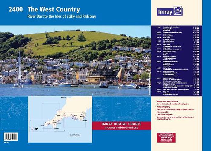
2400.1 Land’s End to Trevose Head 1: 180 000 WGS 84 Includes plans Newquay Bay (1:10 000) and Saint Ives (1:15 000) 2400.2 Approaches to the Isles of Scilly 1: 120 000 WGS 84 2400.3 Isles of Scilly 1: 40 000 WGS 84 Includes plan St Mary’s Road (1:25 000) 2400.4 River Camel 1: 30 000 WGS 84 Includes plan Padstow Harbour (1:10 000) 2400.5 Salcombe Harbour 1: 15 000 WGS 84 Includes plan Salcombe (1:9000) 2400.6 River Yealm 1: 12 500 WGS 84 Includes plan Continuation of River Yealm (1:15 000) 2400.7 River Fowey 1: 9000 WGS 84 Includes plan Continuation to Lostwithiel (1:20 000) 2400.8 Dartmouth to Fowey 1: 150 000 WGS 84 Includes plans Polperro (1:3500) and Looe (1:10 000) 2400.9 Fowey to Lizard Point 1: 110 000 WGS 84 Includes plans Mevagissey Harbour (1:3500) and Gorran Haven (1:30 000) 2400.10 Lizard Point to Land’s End 1: 75 000 WGS 84 Includes plans Penzance (1:12 000), Newlyn Harbour (1:10 000) and Mousehole (1:5000) 2400.11 Helford River 1: 17 000 WGS 84 Includes plan Continuation of Helford River to Gweek (1:17 000) 2400.12 Falmouth Harbour 1: 20 000 WGS 84 Includes plans Mylor Yacht Harbour (1:10 000), Falmouth Marina (1:5000) and Falmouth Inner Harbour (1:10 000) 2400.13 Plymouth Harbour 1: 20 000 WGS 84 Includes plans King Point & Millbay Marinas (1:10 000) and Continuation of River Yealm (1:20 000) 2400.14 Plymouth to Saltash and Saint Germans 1: 20 000 WGS 84 Includes plans Mayflower Marina (1:5000), Sutton Harbour and Queen Anne’s Battery Marina (1:7500) and Plymouth Yacht Haven (1:5000) 2400.15 Saint Mary’s, Tresco and Surrounding Islands 1: 20 000 WGS 84 2400.16 River Dart 1: 15 000 WGS 84 Plans Kingswear, Continuation to Totnes Various individual sheets of this chart pack are available separately. These form part of our ‘small format Y chart series’ that mirror coverage of charts from the corresponding atlas and printed A2 size. For details of these please see their individual web page (Y43, Y44, Y45, Y46, Y47, Y48, Y49 and Y50).
$9.00 standard shipping within Australia
FREE standard shipping within Australia for orders over $100.00
Express & International shipping calculated at checkout
2400.1 Land’s End to Trevose Head 1: 180 000 WGS 84 Includes plans Newquay Bay (1:10 000) and Saint Ives (1:15 000) 2400.2 Approaches to the Isles of Scilly 1: 120 000 WGS 84 2400.3 Isles of Scilly 1: 40 000 WGS 84 Includes plan St Mary’s Road (1:25 000) 2400.4 River Camel 1: 30 000 WGS 84 Includes plan Padstow Harbour (1:10 000) 2400.5 Salcombe Harbour 1: 15 000 WGS 84 Includes plan Salcombe (1:9000) 2400.6 River Yealm 1: 12 500 WGS 84 Includes plan Continuation of River Yealm (1:15 000) 2400.7 River Fowey 1: 9000 WGS 84 Includes plan Continuation to Lostwithiel (1:20 000) 2400.8 Dartmouth to Fowey 1: 150 000 WGS 84 Includes plans Polperro (1:3500) and Looe (1:10 000) 2400.9 Fowey to Lizard Point 1: 110 000 WGS 84 Includes plans Mevagissey Harbour (1:3500) and Gorran Haven (1:30 000) 2400.10 Lizard Point to Land’s End 1: 75 000 WGS 84 Includes plans Penzance (1:12 000), Newlyn Harbour (1:10 000) and Mousehole (1:5000) 2400.11 Helford River 1: 17 000 WGS 84 Includes plan Continuation of Helford River to Gweek (1:17 000) 2400.12 Falmouth Harbour 1: 20 000 WGS 84 Includes plans Mylor Yacht Harbour (1:10 000), Falmouth Marina (1:5000) and Falmouth Inner Harbour (1:10 000) 2400.13 Plymouth Harbour 1: 20 000 WGS 84 Includes plans King Point & Millbay Marinas (1:10 000) and Continuation of River Yealm (1:20 000) 2400.14 Plymouth to Saltash and Saint Germans 1: 20 000 WGS 84 Includes plans Mayflower Marina (1:5000), Sutton Harbour and Queen Anne’s Battery Marina (1:7500) and Plymouth Yacht Haven (1:5000) 2400.15 Saint Mary’s, Tresco and Surrounding Islands 1: 20 000 WGS 84 2400.16 River Dart 1: 15 000 WGS 84 Plans Kingswear, Continuation to Totnes Various individual sheets of this chart pack are available separately. These form part of our ‘small format Y chart series’ that mirror coverage of charts from the corresponding atlas and printed A2 size. For details of these please see their individual web page (Y43, Y44, Y45, Y46, Y47, Y48, Y49 and Y50).
Search our extensive online catalogue.
