Readings Newsletter
Become a Readings Member to make your shopping experience even easier.
Sign in or sign up for free!
You’re not far away from qualifying for FREE standard shipping within Australia
You’ve qualified for FREE standard shipping within Australia
The cart is loading…


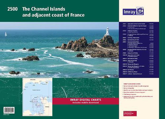
Approaches to the Channel Islands (1: 500 000)
Cap Barfleur to Alderney (1: 150 000) Plans Cherbourg (1:40 000) Port de Chantereyne (Cherbourg) (1:10 000)
Alderney & Burhou (1: 25 000) Plan Alderney Harbour (1:12 500)
Passages Between Alderney & Guernsey (1: 150 000) Plan Dielette (1:15 000)
Guernsey, Herm & Sark (1: 60 000)
East Guernsey & Herm (1: 25 000)
Guernsey & Sark Plans (various scales) Plans St Peter Port & Havelet Bay (1:6000) Beaucette Marina (1:10 000) Sark Anchorages (1:25 000) Guernsey - South Coast Anchorages (1:25 000)
Passages Between Guernsey & Jersey (1: 150 000) Plan Carteret (1:22 500)
Jersey & Les Ecrehou (1: 75 000)
Approaches to St Helier (1: 30 000) Plan St Helier Harbour (1:15 000)
East Coast of Jersey (1: 25 000)
Jersey to Granville (1: 150 000) Plan Granville (1:30 000)
Plateau des Minquiers (1: 50 000)
Plateau des Minquiers to St-Malo (1: 150 000) Plan St-Malo Approaches (1:55 000)
Iles Chausey (1: 25 000)
St-Malo & La Rance (1: 15 000)
La Rance - Cancaval to Lyvet (1: 25 000)
For this 2017 edition the latest depth surveys have been applied. There has been general updating throughout. This edition has tidal stream information is included.
$9.00 standard shipping within Australia
FREE standard shipping within Australia for orders over $100.00
Express & International shipping calculated at checkout
Stock availability can be subject to change without notice. We recommend calling the shop or contacting our online team to check availability of low stock items. Please see our Shopping Online page for more details.
Approaches to the Channel Islands (1: 500 000)
Cap Barfleur to Alderney (1: 150 000) Plans Cherbourg (1:40 000) Port de Chantereyne (Cherbourg) (1:10 000)
Alderney & Burhou (1: 25 000) Plan Alderney Harbour (1:12 500)
Passages Between Alderney & Guernsey (1: 150 000) Plan Dielette (1:15 000)
Guernsey, Herm & Sark (1: 60 000)
East Guernsey & Herm (1: 25 000)
Guernsey & Sark Plans (various scales) Plans St Peter Port & Havelet Bay (1:6000) Beaucette Marina (1:10 000) Sark Anchorages (1:25 000) Guernsey - South Coast Anchorages (1:25 000)
Passages Between Guernsey & Jersey (1: 150 000) Plan Carteret (1:22 500)
Jersey & Les Ecrehou (1: 75 000)
Approaches to St Helier (1: 30 000) Plan St Helier Harbour (1:15 000)
East Coast of Jersey (1: 25 000)
Jersey to Granville (1: 150 000) Plan Granville (1:30 000)
Plateau des Minquiers (1: 50 000)
Plateau des Minquiers to St-Malo (1: 150 000) Plan St-Malo Approaches (1:55 000)
Iles Chausey (1: 25 000)
St-Malo & La Rance (1: 15 000)
La Rance - Cancaval to Lyvet (1: 25 000)
For this 2017 edition the latest depth surveys have been applied. There has been general updating throughout. This edition has tidal stream information is included.
Search our extensive online catalogue.
