Readings Newsletter
Become a Readings Member to make your shopping experience even easier.
Sign in or sign up for free!
You’re not far away from qualifying for FREE standard shipping within Australia
You’ve qualified for FREE standard shipping within Australia
The cart is loading…


Plans included:
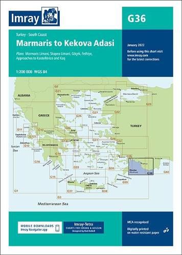
Marmaris Limani (1:50 000) Skopea Limani (1:100 000) Goecek (1:25 000) Fethiye (1:35 000) Approaches to Kastellorizo and Kas (1:75 000)
Imray-Tetra charts for the Ionian and Aegean are widely acknowledged as the best available for the cruising sailor. They combine the latest official survey data with first-hand information gathered by Rod and Lucinda Heikell. The chart is designed to be used alongside Imray pilot guides of the area. Like all Imray charts, they are printed on water resistant Pretex paper for durability, and they include many anchorages, facilities and inlets not included on official charts.
This edition includes the latest official data combined with additional information sourced from Imray’s network to make it ideal for small craft. The latest harbour developments at Goecek are included as is latest official bathymetric survey data. There has been general updating throughout.
$9.00 standard shipping within Australia
FREE standard shipping within Australia for orders over $100.00
Express & International shipping calculated at checkout
Plans included:
Marmaris Limani (1:50 000) Skopea Limani (1:100 000) Goecek (1:25 000) Fethiye (1:35 000) Approaches to Kastellorizo and Kas (1:75 000)
Imray-Tetra charts for the Ionian and Aegean are widely acknowledged as the best available for the cruising sailor. They combine the latest official survey data with first-hand information gathered by Rod and Lucinda Heikell. The chart is designed to be used alongside Imray pilot guides of the area. Like all Imray charts, they are printed on water resistant Pretex paper for durability, and they include many anchorages, facilities and inlets not included on official charts.
This edition includes the latest official data combined with additional information sourced from Imray’s network to make it ideal for small craft. The latest harbour developments at Goecek are included as is latest official bathymetric survey data. There has been general updating throughout.
Search our extensive online catalogue.
