Readings Newsletter
Become a Readings Member to make your shopping experience even easier.
Sign in or sign up for free!
You’re not far away from qualifying for FREE standard shipping within Australia
You’ve qualified for FREE standard shipping within Australia
The cart is loading…


Plans included:
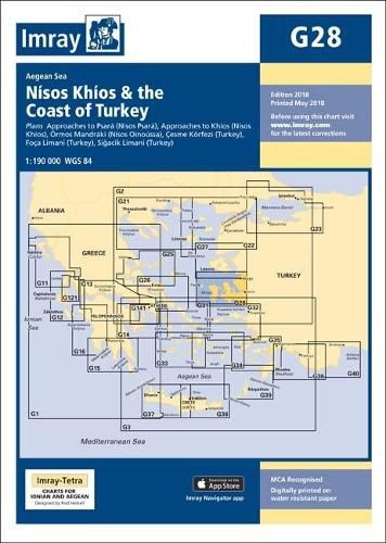
Approaches to Psara (Nisos Psara) (1:15,000) Approaches to Khios (Nisos Khios) (1:20,000) Ormos Mandraki (Nisos Oinoussa) (1:8,000) Cesme Koerfezi (Turkey) (1:18,000) Foca Limani (Turkey) (1:20,000) Sigacik Limani (Turkey) (1:18,000)
On this 2018 edition full details of the new TSS schemes are shown at Izmir Koerfezi, Candarli Koerfezi and Nemrut Koyu; revised depths and harbour developments are shown at Psara, Khios, Cesme and Foca; the Sigacik Limani sketch plan has been replaced with a fully WGS84-compatible version; the latest known depths, restricted areas and marine farms have been applied to the main chart; and details of the recently deployed AIS transmitters are shown across the chart.
$9.00 standard shipping within Australia
FREE standard shipping within Australia for orders over $100.00
Express & International shipping calculated at checkout
Plans included:
Approaches to Psara (Nisos Psara) (1:15,000) Approaches to Khios (Nisos Khios) (1:20,000) Ormos Mandraki (Nisos Oinoussa) (1:8,000) Cesme Koerfezi (Turkey) (1:18,000) Foca Limani (Turkey) (1:20,000) Sigacik Limani (Turkey) (1:18,000)
On this 2018 edition full details of the new TSS schemes are shown at Izmir Koerfezi, Candarli Koerfezi and Nemrut Koyu; revised depths and harbour developments are shown at Psara, Khios, Cesme and Foca; the Sigacik Limani sketch plan has been replaced with a fully WGS84-compatible version; the latest known depths, restricted areas and marine farms have been applied to the main chart; and details of the recently deployed AIS transmitters are shown across the chart.
Search our extensive online catalogue.
