Readings Newsletter
Become a Readings Member to make your shopping experience even easier.
Sign in or sign up for free!
You’re not far away from qualifying for FREE standard shipping within Australia
You’ve qualified for FREE standard shipping within Australia
The cart is loading…


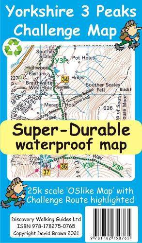
Yorkshire 3 Peaks Challenge Map and Guide at 25k scale with challenge route specially highlighted. We licence OS 50k scale mapping which is then doubled in size to produce a 25k map but the features, text and logos are now doubled in size making them much easier to read under challenge conditions. Y3P 12 Hour Challenge Route is added and specially highlighted so that the route stands out against the OS background map. Then we add the additional detail you might need including the popular Challenge starting points of the Pen Y Ghent Cafe (Horton), Station Inn (Ribblehead) and the Hill Inn (Chapel-le-Dale). Then we add the four parts of our Challenge Guide; 1 Horton to Pen-y-ghent, 2 Pen-y-ghent to Whernside, 3 Whernside to Ingleborough, 4 Ingleborough to Horton. The gps track and 47 waypoints (highlighted on the map) of our Challenge is available as a free gpx file download, and can be used on all gps phone apps and gps units. On the reverse of the map sheet is our Locator Map using OS Opendata showing the location of, and access to, the Yorkshire 3 Peaks Challenge relative to a wide area of England. The result is a double sided 600mm by 600mm map design. We then print the map design on a 100 micron plastic substrate using a special UV curing inks process on the UK’s only press capable of using this latest technology. The result is a lightweight map that is both waterproof and tearproof, and fully recyclable, that will survive anything your Yorkshire 3 Peaks Challenge can throw at it and afterwards will fold up like new.
$9.00 standard shipping within Australia
FREE standard shipping within Australia for orders over $100.00
Express & International shipping calculated at checkout
Yorkshire 3 Peaks Challenge Map and Guide at 25k scale with challenge route specially highlighted. We licence OS 50k scale mapping which is then doubled in size to produce a 25k map but the features, text and logos are now doubled in size making them much easier to read under challenge conditions. Y3P 12 Hour Challenge Route is added and specially highlighted so that the route stands out against the OS background map. Then we add the additional detail you might need including the popular Challenge starting points of the Pen Y Ghent Cafe (Horton), Station Inn (Ribblehead) and the Hill Inn (Chapel-le-Dale). Then we add the four parts of our Challenge Guide; 1 Horton to Pen-y-ghent, 2 Pen-y-ghent to Whernside, 3 Whernside to Ingleborough, 4 Ingleborough to Horton. The gps track and 47 waypoints (highlighted on the map) of our Challenge is available as a free gpx file download, and can be used on all gps phone apps and gps units. On the reverse of the map sheet is our Locator Map using OS Opendata showing the location of, and access to, the Yorkshire 3 Peaks Challenge relative to a wide area of England. The result is a double sided 600mm by 600mm map design. We then print the map design on a 100 micron plastic substrate using a special UV curing inks process on the UK’s only press capable of using this latest technology. The result is a lightweight map that is both waterproof and tearproof, and fully recyclable, that will survive anything your Yorkshire 3 Peaks Challenge can throw at it and afterwards will fold up like new.
Search our extensive online catalogue.
